

History rolls like a obwarzanek
Although it’s hard for me to believe, the hobby project tentatively, and probably ultimately, named 100KRK has stopped being just an idea. What started as a loose concept is beginning to take a concrete form. For now, it’s mostly code and graphics, but the project is genuinely coming to life.
The service is being developed in a rather common “live” mode, so the visual identity and the concept itself are refined on the go. The design created with the help of Stitch UI has been slightly modified, with styles adapted to my blog. Most importantly, there’s already a working seed. The domain has been reserved, as well as social media channels—at least as much as possible. One day produced the logic, and the next day the first data were added.
Initially, the logo was inspired by the motif of Wawel’s gates, specifically the cathedral on the hill. It has character, but such forms are usually too complex for a web project. It will be replaced by a simple logotype—more readable, scalable, and easier to use in different contexts. 100KRK is a hobby project, so at this stage, nothing more is needed.

I hadn’t originally planned a symbol, but the icon needs something. Since the service is about local history and exploring the area on two wheels, the natural choice is a krakowski obwarzanek. Round, regionally connected, and recognizable. All that’s left is to add logic to ban users from commenting with the word “precel,” and done 😉
Functionality
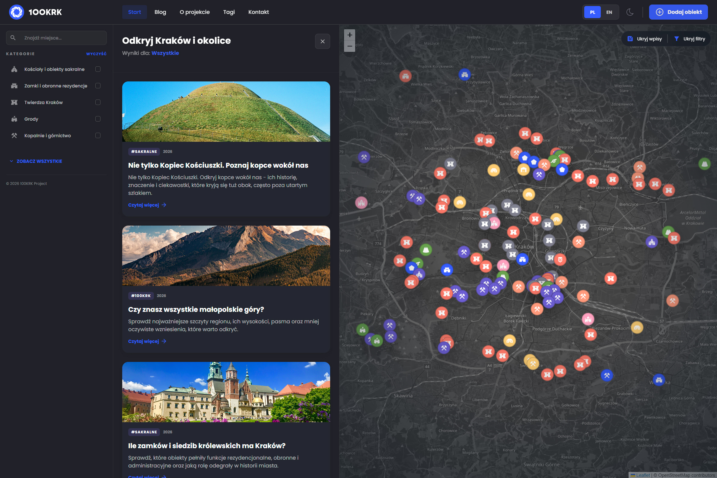
100KRK is intended as a slightly more complex, thematically focused blog. It should allow documenting explored areas and presenting routes in a more interactive way. The interface may seem complex, but that’s simply due to my meticulous approach to the subject.
After selecting interesting categories, posts tagged with the filtered object classes automatically appear. I’m still considering adding an option to display a list of filtered objects, but I’m not yet sure if it would be truly necessary or useful.
There will definitely be an additional, more “nerdy” feature for filtering objects by the periods they belong to. Whether this will be a year-range slider or a set of checkboxes is still undecided. The second option offers greater flexibility, especially when filtering periods beyond classic historical frameworks. The region is full of traces of human activity that are much older—and not only from the Middle Ages.
Besides castles, forts, churches, and other historical objects, the service will also cover sites whose chronology reaches at least the Pleistocene. At least—because, for example, visiting the fairly well-known Łom Karmelicki in Dębnik is not just a late medieval site, but also has significantly older Devonian traces.
Only a few look at these issues in such a wide temporal perspective, yet what “comes to the surface” really shapes the landscape and the experience of exploring routes. This is exactly the kind of local insight the service aims to highlight.
Kraków Fortress
Festung Krakau is one of the best-documented groups of historical objects in the city area. Still, 100KRK is already likely one of the most comprehensive and accessible services presenting them.
This is something worth showing off.
It’s not a detailed approach—the plan is not to describe every object individually, but to redirect users to sources that cover the subject best. So far, however, I haven’t seen a solution that gathers all objects on a single, coherent, interactive map.
Currently, almost all batteries, redoubts, forts, bastions, and ammunition bunkers have been added—both those well-preserved and those that no longer exist or are only visible as relics. A few gates, bridges, barriers, intersections, and smaller and larger defensive works remain. Once these are added, I’ll be truly satisfied with the result.
Thematic services describe fortress remnants in more detail, but rarely do all objects appear on a single map. OpenStreetMap allows filtering fortress objects but doesn’t include those that no longer exist. For a fuller picture of the fortress as a system, this is crucial.
Plans
Although 100KRK is more than just a map and web service, I’ll need to focus on it for some time. The work will likely not be limited to key corrections and expanding filtering functionality.
Additional map layers will certainly appear. First, not everyone prefers a dark theme, and it wouldn’t match the service’s light style if the user chooses that. Second, since the data cover Kraków Fortress objects (earthworks) as well as settlements, mines, and burial mounds, it’s worth allowing users to examine their construction in a more geometric form. For this purpose, besides the 3D view—which isn’t available for less popular areas—the LIDAR layer is perfect. It would also be great to add historical maps, though implementing them fairly, without unauthorized use of data, could be challenging.
Search options by object category and chronology will likely be complemented by filters for architectural styles. After all, Lesser Poland is rich in Romanesque and Gothic heritage. And there are many lesser-known places worth visiting.
An archive photo gallery also tempts me, but I’m unsure if I want to deal with the associated copyright issues. While photos shared on social media generally attract little attention, publishing them on a well-known, stable website could draw those who attempt to raise funds in a somewhat unethical manner.
For the web part of the service, I’m still considering enabling route planning by selected locations, but this is open for discussion—users of such apps rarely know what they want and usually prefer ready-made routes. These, in any case, will be prepared without AI involvement.
Anyway, the outline of the work is clear—it’s time to start implementing. t.b.c.